Thursday, March 31, 2016

Spectrometry


Name: Trey Riley
Lab Experiment #8: Spectroscopy
Date: March 30, 2016


Abstract
          The purpose of this lab and this report is to become familiarized with the chemical compositions of elements, and the practices and methods of determining elemental composition. A spectrometer was used, as well as a diffraction grating, to see the visible spectra produced by different elemental gases, as well as continuous spectra from certain light sources. Seven sources of light were observed with a spectrometer. Our goal was to determine which element made up the gas by using data recorded from observations with the spectrometer. Once the data was recorded, our data was either confirmed or denied by online sources. These sources eventually lead us to the conclusion of the six different elements present in each light source.

Introduction
            This report has three distinctive experiments. The purpose in doing the first experiment is to become familiar with a diffraction grating and a spectrometer. A ceiling light was viewed with the diffraction grating, and the spectrum observed was to be recorded. The spectrometer was then calibrated on a light source to use for the rest of the experiment. Important features of the spectrometer were to be noted, such as the wavelength scale labeled from 700 to 400 nanometers from left to right. Proper usage was demonstrated and repeated by students, and thus the rest of the experiment began.
Spectrometer used during experiment

The second experiment conducted consisted of viewing an incandescent bulb with the spectrometer. A continuous spectrum was to be observed if the spectrometer was calibrated correctly. The patterns of color were to be noted on the wavelength scale. The end of the spectrum was also to be noted on the far left and far right to indicate the wavelength limits of the sensitivity of the human eye.
           
In the third experiment, several spectra of elements were observed at different stations. The spectrometer was to be used, and specific wavelengths were to be recorded. The color of the gas, as well, was to be noted to help indicate which element is within the unlabeled gas tubes. Specific elements emit only one color of light to the human eye. This color that we see is actually all of the different colors in the elements spectrum blended together. Pictures were to be taken of our spectra that we observed, but taking the picture was much harder than expected, viewing the spectrum through the narrow slit of the spectrometer.
           
Procedures
Throughout each individual experiment, a spectrometer or diffraction grating was used. When determining composition of gases, online sources were consulted to confirm or deny or results. If an ambiguous answer was given by an online source, another was consulted until a confirmation was given that multiple students could agree upon. Pictures were not taken of the spectrum I observed due to the difficulty of the operation. Spectra of elements were found online through a spectrometer that closely resembled what I viewed.

Results and Discussion
Experiment One
            The continuous spectrum was observed from the ceiling light using the diffraction grating. The spectrometer was calibrated, and all important features were known. In the picture, the closest to the light source is violet, while the furthest is red.
Diffraction grating of ceiling light

Experiment Two
            The continuous spectrum was observed using the spectrometer. The wavelength limits of the sensitivity of the human eye were though to be 700 to 400 nanometers, but the exact quantities seemed to be 660 and 420.
Continuous spectrum observed from desk lamp

Experiment Three
            Seven stations were observed with a spectrometer. All measurements are in nanometers, (10^(-9))m.
·         
      Station 1: Continuous spectrum observed from incandescent light bulb
·         Station 2: Emission lines observed at 655, 590, 490 
Hydrogen emission spectrum
      Observed Gas: Faint Purple 
Hydrogen gas
      Conclusion: Hydrogen
·         Station 3: Multiple emission lines observed from 700-580, 540, 535, 505  
Neon emission spectrum
     Observed Gas: Bright Red Orange 
Neon gas
      Conclusion: Neon
·         Station 4: Emission lines observed at 590, 560, 510 and 430 
Krypton emission spectrum
     Observed Gas: Bright Faint Blue 
Krypton gas
      Conclusion: Krypton
·         Station 5: Emission lines observed at 700, 660, 580, 495, 485, 463, 420, 400 
Helium emission spectrum
      Observed Gas: Faint Orange 
Helium gas
      Conclusion: Helium
·         Station 6: Emission lines observed at 615, 590, 575, 545, 495, 485 
Sodium emission spectrum
     Observed Gas: Bright Orange/Yellow 
Sodium gas
      Conclusion: Sodium
·         Station 7: Emission lines observed at 575, 545, 490, 430, 400 
Xenon emission spectrum
     Observed Gas: Bright White 
Xenon gas
      Conclusion: Xenon
           

Conclusion

The objective of this lab and report was to gain a better understanding of spectrometry. This was achieved through use of a diffraction grating and spectrometer. Different spectra were observed through different methods. Incandescent bulbs produce a continuous spectrum through a diffraction grating and a spectrometer. Each separate gas tube held a different gas with different and unique spectra. Data did not directly prove one gas, but definitely implied one gas. Some source for error may have been light from other station being observed in the spectrometer causing false readings, or possibly reading some spectra of the oxygen and nitrogen gas in air. Dealing with each type of spectra helped students gain a better and more practical application of how spectrometry is used in astronomy. 

Tuesday, March 22, 2016

The Surface of Mars


Lab: The Surface of Mars


Abstract

In this lab, students study several images of Mars and use their observations to draw conclusions and make inferences as to how surface features came to be, why the elevation of the planet is so different between two hemispheres, and why scientists chose to land spacecraft where they did on Mars. Students also determine why some images of Mars look different from one another and what these differences can tell us.

Introduction

As our next-door-neighbor in the solar system, Mars has been a subject of observation of people on Earth for hundreds of years. While not all observations led to correct conclusions, as in the case of Percival Lowell, these observations have provided us with much information on the surface of Mars, including its differing features, compostion, and elevation.

Procedure

 Materials: Google Mars, maps and images provided with lab.

A: In part A, students examined sketches of the surface of Mars by Percival Lowell and compared them to two images of Mars taken by the Hubble Space Telescope in 2003. Students answered questions over the sketches and images.

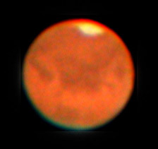
B: In part B, students analyze two typical images of Mars that can be obtained with a telescope on the ground and answered questions over them.

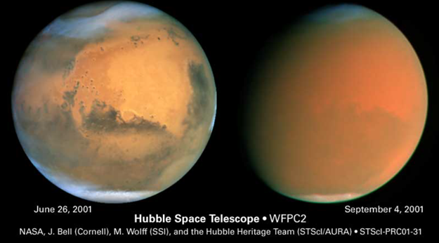
C: Students are shown two images of Mars taken months apart and answer questions regarding the differences in the pictures.

D: In part D, students use maps to answer questions regarding Mars' elevation, cratering, and the landing sites of several missions to Mars.

E: Students use features on Google Mars to locate and examine the landing sites of the Mars Exploration Rovers. Students then answer questions on these landing sites, Niger Valles, and the information that maps of different wavelengths of light can give.

F: Students are given a link to view a webpage of NASA space missions. They are then asked to consider the goals of a mission to Mars if they were planning it.

Results and Discussions

A: 
Percival Lowell thought he was seeing evidence of advanced intelligent people on Mars, as evidenced by vast canals spanning the planet.

1. Why would Percival think he saw canals? 

      Lowell might have believed he saw canals because the dark lines in his drawings do, in fact, resemble canals which flow from a large body of water (large dark area) farther into the planet. This misconception is understandable because at the time of Lowell's observation, ships were a major mode of transportation, especially for the movement of goods. Therefore, the features on Mars' surface cause shadow or dark areas that somewhat resemble a water canal system on Earth.

2. What was Percival seeing instead?

     Lowell was seeing darker areas on the surface of Mars, which could represent a number of things, including changes in elevation and differences in composition, such as possible volcanic rock leftover from previous volcanic activity. 

B:

1. What are the main features that you can identify from the images taken from the surface of the Earth? What might they be caused or produced by? Can you see anything that resembles craters, mountains, or seas?

      In the two images of Mars, one can easily identify light and dark areas, which represent differences in elevation and composition. Also, one of the images shows a white area at Mars' south pole, which looks like a polar cap. These different light and dark areas could be caused by volcanic activity. The images do possess some semi-circular features that resemble craters, there are long strings of dark areas that resemble mountain ranges, and the dark/lower areas could indicate the existence of ancient seas on the surface of Mars. The images are very fuzzy, however, and it is difficult to identify anything with clarity.

2. How are these ground-based images similar to the Hubble Space Telescope image? How are they different? Why might our views of Mars be changing?

       The ground-based images and the Hubble Space Telescope image have similar colors, and corresponding areas in the images are generally the same shade of light or dark. That is,we view lightness and darkness on the surface in the same areas. The ground-based images lack the clarity afforded by the Hubble Space Telescope however, and it is much more difficult to identify  features in these images. Also, the images are all of different views of the surface of Mars, and these views show us different features. Our view of Mars changes because of the orbit and rotation of both Earth and Mars, which move at very different rates. Therefore, our perspective is constantly changing.

3. Does Mars have a lot of visiblee craters like the moon and Mercury? What does this mean?

    No, the surface of Mars does not have nearly as many craters as the moon or Mercury. This means that the surface of Mars is fairly new, and has been smoothed over since the violent period of collisions in our solar system.

4. The "S"-shaped sequence of Mars-shaped images clearly show Mars appearing to change in size. They were take over several months. What is going on?

      This image shows the changing perspective of Mars from the Earth as each planet continues on its respective orbit around the sun. The apparent retrograde motion in the middle if the image occurs when one planet laps the other in their orbits.

C:

1. What are the main features you can identify in these images? 

     There is a large, smooth, lighter area in the left image. This area seems to have some dark spots, which could be mountains. That area is surrounded by darker land. The north and south poles have some sort of ice. 

2. How are the two images similar and different?

    Both images show portions of this lighter, smooth area, which is then surrounded by darker matter. Both images reveal ice at the poles. While both images are slightly hazy, the left image has much more detail than the right image. Also, they are showing slightly different areas of the surface of Mars. 

3. What is going on here?

     The first image, taken in June, shows the surface of Mars in direct sunlight (the Sun is in front of Mars), The second image shows the light of the Sun coming from the right side. The light is much less direct, therefore, and the image is less detailed.

D:

1. What do the four highest features on Mars appear to be? What could that mean?

     The four highest features on Mars all appear to be volcanoes. This could mean that Mars has seen volcanic activity, which explains the young surface with few pockmarks. 

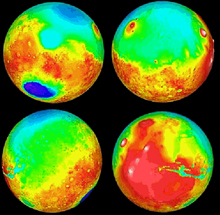
2. In the elevation map of the planet, what is the most notable difference between the Northern and Southern hemispheres? What might this mean?

The Northern hemisphere is much lower in elevation than the Southern hemisphere and contains very few craters, while the Southern hemisphere is moderately cratered. This might mean the the Northern hemisphere was once covered in a sea of liquid, explaining the lowered elevation and lack of craters. This could also mean that the Northern hemisphere has been recently resurfaced by molten rock.

3. Which hemisphere appears to have most of the impact craters?

    The Southern hemisphere contains most of the craters, with the south east quadrant of the provided elevation image being the most heavily-cratered area.

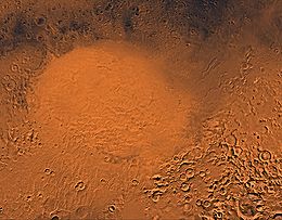
4. What appears to be the largest impact crater on Mars?

     Hellas Planitia appears to me to be the largest impact crater on Mars. 


5. Find the landing sites for the US Viking I and II spacecraft. What type of terrain did they land in?What do you think were the reasons for choosing these particular areas? From the elevation map, were they high or low elevation regions on the surface?

      The spacecraft landed in smooth areas on the younger portions of Mars' surface. These areas were probably chosen for the efficiency of landing a spacecraft on smooth terrain as well as to study the composition of newer parts of Mars' surface. Both spacecraft landed in areas of low to mid-low elevation.

6. Find the landing sites of the US Mars Pathfinder, Spirit, Opportunity and Curiosity spacecraft. What type of terrain did they land in? What could have been the reasons for choosing these areas?

Pathfinder - smooth, flat terrain; near the beginning of higher elevation. Most likely landed here to study composition of surface material.
Spirit - terrain less smooth, but not rough. Near a rift in the ground. This is the landing site to study the composition of surface material and the nature or history of the nearby feature in the ground.
Opportunity - landed in low-to-medium elevation, some cratering nearby. Probably landed here to study this surface that is younger than the oldest surfaces on Mars, but younger than the youngest surfaces in the Northern hemisphere.
Curiosity - rough terrain; landed near the equator at medium elevation; near the border between higher and lower elevation. This landing site was chosen to study the area between the extremes in elevation and to study the surface of Mars near its equator.

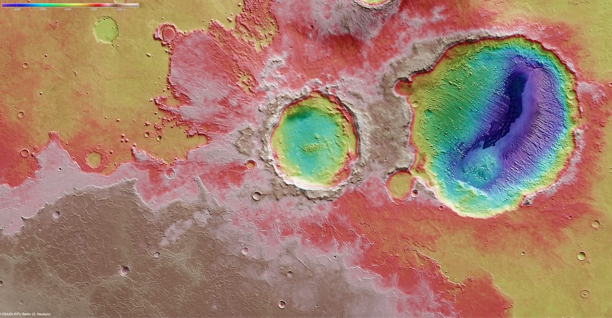
7. The Soviet Mars 3 spacecraft was the first soft landing on Mars. After 14.5 seconds, transmission from the surface stopped. Give a reasonable explanation as to why it may have fallen over. 

Mars 3 could have fallen over because there are many craters within the Ptolemaeus Crater, including tangential craters (with the rims touching). The presence of such cratering creates a rough terrain that would be easy for a spacecraft to tip over on.

E:
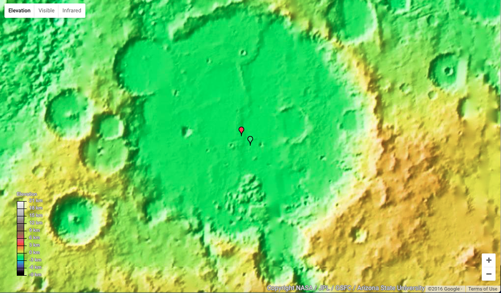
 Search for the landing sites of the Mars Exploration Rovers. They landed at Gusev Crater and Meridiani Terra

1. Describe each landing site, noting the features present and the elevation. Suggest reasons why these particular places might have been chosen.

Spirit: Gusev Crater - the landing site is smooth terrain, with low-to-medium elevation and more craters surrounding the site. This site was probably chosen for its proximity to a feature that looks like it may have once been a volcano.

Opportunity: Meridiani Terra - The terrain is somewhat smooth with some nearby craters. Again, low-to-medium elevation, but the landing site is on the border between lower elevation in the North and higher elevation in the South. This is probably one reason that this landing site was chosen, as well as its proximity to a mountain range and the ability to study surface composition. 

2. Look at each landing site in the visible and infrared and determine whether you can see things in one wavelength that you cannot see in the other. 

Spirit - In infrared, there exists a dark, cold area that resembles ice. The area streaks out in jagged, ice or frost-like patterns. This feature is much less noticeable in visible wavelengths, and appears only vaguely darker than the surrounding land. 

Opportunity - many of the areas that appear darker in visible light then appear brighter (indicating warmth) in infrared. This is interesting, and indicates that the lower elevation is warmer than the higher elevation. 

3. Search for Niger Valles on Google Mars. Follow this feature from its high elevation to its low elevation (beginning to end). What seems to be going on here?

   This feature resembles a valley cut into land by the flow of a liquid (maybe water) from a point of high elevation to low elevation. In other words, it resembles the path of a river.

F:
 If I were planning the next mission to Mars, its goals would be to investigate the history of water or water-ice on the Martian surface, to study the features that resemble the paths of rivers in order understand how they came to be, and to gather data to determine whether a permanent human settlement on Mars is a good idea.

Conclusion

By studying the surface of Mars, we can often gain answers to many questions, such as "what areas of the surface are younger than other areas?" and "what features do you observe, and how might they have came to be there?" However, observations can lead to even bigger, more mysterious questions. For instance, why is the Northern hemisphere of Mars at a much lower elevation than the Southern hemisphere? Was the north once covered by a sea of some sort, or is there another explanation? Unfortunately, not all questions can be answered right away, and many questions regarding Mars and its history require much more research before answers become clear. By studying the surface features, elevation, and composition of different areas of Mars, we are able to gather more data, make more inferences and conclusions, and ultimately learn more about Mars, which leads us closer to answering these big, mysterious, perhaps unanswerable questions.

Surface of Mars Lab

Introduction:
The images of Mars that have recently become available are tremendously useful in researching the planet. In this lab concerning Mars, we were able to discover more about the planet. We observed its surface using different materials. In addition to viewing the appearance of the planet’s surface, we also observed its physical makeup and became aware of the qualities of its surface.

Procedures:
In order to complete this lab, I had to utilize virtual maps of Mars, including http://www.google.com/mars/. I used the different available online images of Mars to view and compare its physical traits. Using additional sources to view Mars’ surface, I was able to further understand its complexities.

Results and Discussion:
A)
Percival Lowell was a businessman and astronomer who died 100 years ago in 1916.  This is what Percival Lowell recorded that he saw on the surface of Mars when he looked through his telescope:
lowell-mars-canals-02.jpg
Compare Percival Lowell's drawings to one of the best images taken with the Hubble Space Telescope in 2003:
mars0322a.jpg
Percival Lowell thought he was seeing evidence of advanced intelligent people on Mars, es evidenced by vast canals spanning the planet.
  1. Why would Percival think he saw canals? (Hint: think about our own civilization more than 100 years ago. What were the dominant modes of transportation?)
Lowell probably described canals because there was no such thing as a real road system yet, only railroads and rivers.
   2.   What was Percival seeing instead?
He was probably seeing the canyons on Mars.

B)
Here are typical sets of images that can be obtained with Mars from telescopes on the ground (with digital cameras and careful observing practices):
sred2_s02.jpg030826-Mars-Coolpix-Registax-Photoshop-for-web.jpgpasted image 0.png

  1. What are the main features that you can identify from the images taken from surface of the Earth? What might be they caused by or produced by? Can you see anything that resembles craters, mountains, or seas?
From the surface of Earth, you can see the drastic change in elevation. These could be a result of volcanoes, lava flow, and possibly water movement. Yes, there is a possible sea visible.
  1. How are these ground-based images similar to the Hubble Space telescope image? How are they different? Why might our views of Mars be changing? Are they more detailed or less detailed?
You can still see the same pattern of the different shades of red. The Hubble images are much more clear. We have developed telescopes equipped with adaptive optics, which negate the atmospheric turbulence. Our views are more detailed as a result of this.
  1. How are these ground-based images similar to the Hubble Space Telescope image? How are they different? Why might our views of Mars be changing? Are they more detailed or less detailed?
Yes, Mars has a lot of visible craters. This means that it is relatively old.
  1. The “S”-shaped sequence of Mars-shaped images clearly show Mars appearing to change in size. They were taken over several months. What is going on?
It is getting closer and then farther away from the viewer.

C)
Here are two more images taken months apart with the Hubble Space Telescope:
pasted image 0-2.png
  1. What are the main features that you can identify in these images?
Hellas Planitia and Argyre Planitia are the main features visible.
260px-Hellas_Planitia_by_the_Viking_orbiters.jpgCraterDunefield_-_perspective_view_large.jpg
  1. How are these two images similar and different?
The second imagine is the same reddish hue, but is clouded over, obscuring the details that are present in the first image.
  1. What is going on here?
It appears that a dust storm has overtaken the planet.

D)
We first landed on Mars in the 1970s with the Viking missions, and have sent rovers to Mars for the past 20 years since July 4th, 1997, starting with the Mars Pathfinder mission. We have also sent a series of orbiters, including the Mars Global Surveyor spacecraft that operated until its batteries failed in 2006. Currently there are a total of seven spacecraft either orbiting (MAVEN, Odyssey, Express, and Mars Reconnaissance Orbiter) or roving the surface of (Curiosity, Spirit, Opportunity) Mars today. Use the images below. Google Mars shows a false-color relief (elevation) map of the surface of Mars, revealing many details about the planet.
  1. What do the four highest features on Mars appear to be? What could that mean?
The four highest features on Mars appear to be Olympus Mons, Ascraeus Mons, Arsia Mons, and Pavonis Mons.
PIA02820.jpg
  1. In the elevation map of the planet, what is the most noticeable difference between the Northern and Southern hemispheres of Mars? What might this mean?
The Southern Hemisphere is a much higher elevation than the Northern hemisphere, possibly indicating that the Northern hemisphere is a sea.
34936main_planetcollagemid.jpg
  1. Which hemisphere appears to have most of the impact craters?
The Southern hemisphere appears to have the most craters; the Northern hemisphere is nearly crater-free.
  1. What appears to be the largest impact crater on Mars?
Galle Crater Dunes appears to be the biggest crater.
Screen Shot 2016-03-23 at 00.40.37.png
  1. Find the landing sites for the US Viking I and II spacecraft, which touched down on July 20th and September 3rd of 1976 (40 years ago). What type of terrain did they land in? What do you think were the reasons for choosing these particular areas? From the elevation map, were they high or low elevation regions on the surface?
The Viking I and II spacecrafts landed in pretty even terrain, probably because it would be much easier to land where there aren’t many craters. They landed in low regions.
  1. Find the landing site of the US Mars Pathfinder, Spirit, Opportunity and Curiosity spacecraft. What type of terrain did they land in? What could have been the reasons for choosing these areas?
The Pathfinder, Spirit, Opportunity, and Curiosity rovers landed in a little more uneven terrain than the Viking spacecrafts, and are also in a higher elevation zone. They may have wanted to view what it was like in the more moderate elevation areas.
  1. The Soviet Mars 3 spacecraft was the first soft landing on December 2nd, 1971 at the Ptolemaeus Crater on Mars. Find it on your maps (https://en.wikipedia.org/wiki/Mars_3). After 14.5 seconds, transmission from the surface stopped. It may have fallen over, or there was a dust storm raging on Mars at the time that could have fried the electronics. Give a reasonable explanation for why it may have fallen over.
There might have been an extremely powerful dust storm that blew the spacecraft over.

E)
With the Google Mars map views (elevation, visible and infrared):
  1. Search for the landing sites of the Mars Exploration Rovers (Spirit and Opportunity). They landed at Gusev Crater and Meridiani Terra.

  1. Zoom in on each landing site and describe each site as to the features present and their elevations. Suggest reasons why these particular places might have been chosen.
The Spirit rover landed in the middle of a crater, at an elevation of approximately 1.5km below sea level.  The Opportunity rover landed on a plain near a small crater, at about an elevation of 1.5km below sea level.
Screen Shot 2016-03-23 at 00.48.13.png
  1. Look at each landing site in the visible and infrared and determine whether you can see things in one wavelength of light that you cannot see in the other. Describe your findings.
In the infrared view, you can see a bunch of smaller craters and a small mountain near the Spirit landing site, but those features are not noticeable in the visible wavelength. The infrared view of the Opportunity landing site doesn't necessarily offer any new details, however the features present are much more visible.
Screen Shot 2016-03-23 at 00.51.45.png
  1. Search for Niger Valles using the Google Mars search tool. Increase the magnification and follow Niger Valles by eye from its high elevation beginning to its low elevation end. What seems to have been going on here? Describe your findings.
There seems to be a canyon that has eroded into the surface, but as it goes on, it tapers off into a vast area of the same low elevation.

F)
NASA spacecraft continue to explore MARS today. See http://science.nasa.gov/missions/. If you were planning the next mission to Mars, what would its goals be?
If I was planning the next mission to Mars, I’d be trying to find tangible lifeforms.

Conclusion:
I never realized how cool Mars is, or the differences in details that are visible in the different wavelengths of light. I gained a greater appreciation for the “great red planet.”


Surface of Mars Lab
Brooke Masterson
AST 115 H, Plavchan
3/22/2016

Introduction:

Mars.  A terrestrial planet that has fascinated humankind since its discovery.  There have been movies made about life forms on Mars.  Countries who can send spacecraft to Mars to document what is on its surface.  People are puzzled by its redness, its dust storms, its likeness of Earth.  Countries are fascinated with the idea of life forming there in the future. Needless to say, this lab was given to astronomy students in this class in the hopes that these students would learn more than just the funny stories, myths, and basic facts about this interesting planet in our solar system.  It challenges students to know which countries have sent which rovers/landers to its surface and why.  This lab challenges students to predict what is happening on Mars' surface, discover answers using credible sources, and have fun learning there are different ways to look at a planet (visible light, infrared light, ground-base images).  


Purpose of the Lab:

Learn more about the features on Mars' surface.  Learn how to utilize online resources and the differences between fact and fiction when it comes to this loved planet.  Learn how to write a professional lab report that could be replicated if another person wanted to complete this lab too.  

Results and Discussion:

Below in black are the pictures and questions asked in the lab, accompanied by my answers in blue and screenshots from my resources.  

   A)  Percival Lowell was a businessman and astronomer who died 100 years ago in 1916.  This is what Percival Lowell recorded that he saw on the surface of Mars when he looked through his telescope.  Compare Percival Lowell's drawings to one of the best images taken with the Hubble Space Telescope in 2003.

 
Percival Lowell thought he was seeing evidence of advanced intelligent people on Mars, as evidenced by vast canals spanning the planet. 
a.     Why would Percival think he saw canals?  Hint: think about our own civilization more than 100 years ago.  What were the dominant modes of transportation?
                                               i.     One hundred years ago, the main mode of transportation was horses and carriages.  Cars were present in America, but there were only around 8,000 of them (history class fun fact).  Percival probably thought he saw canals because from a far distance, the surface of mars looks like it is a lot of rivers and streams.  I looked up a picture of the Venetian canals, and I can imagine how Percival would mistake Mars’ surface for it. 


                                              Maybe Percival thought that they were canals because canals are not as structured (they can’t really be structured, it is water) as roads are.  But still, having a canal system as a mode of transportation still requires intelligent life forms to create. 

AND

b.     What was Percival seeing instead?
                                               i.     Instead of canals, Percival was seeing dust storms.  Mars has a lot of dust storms, and that explains why Lowell’s drawings and the Hubble’s pictures look different every day. 

B)    Here are typical sets of images that can be obtained with Mars from telescopes on the ground (with digital camera and careful observing practices):


a.     What are the main features that you can identify from the images taken from surface of the Earth?  What might be they caused by or produced by?  Can you see anything that resembles craters, mountains, or seas?
                                               i.     The images of Mars taken from Earth are not very detailed.  However, it still looks like there is possibly ice at the bottom of Mars.  It doesn’t look like there are any mountains or valleys, in my opinion.  I could assume how one could predict there are seas on Mars based on the pictures, but I know that it isn’t good to base that idea on the colors in the false-color pictures. 

b.     How are these ground-based images similar to the Hubble Space Telescope image?  How are they different?  Why might our views of Mars be changing?  Are they more detailed or less detailed?
                                               i.     The ground-based images are less detailed than the Hubble Space Telescope images (not that you can tell with the pictures of the pictures I supplied here, but there is a huge difference).  They are different in other ways too.  It looks like there are different dust storms raging on Mars on the days the pictures were taken, or there are different compositions on Mars.  The pictures are similar because one can probably recognize all of the pictures are of Mars – due to the possible ice caps/high elevation points on Mars’ north and south poles. 

c.      Does Mars have a lot of visible craters like the moon at Mercury?  What does this mean?
                                               i.     Mars has less visible craters on it than the Moon.  Most of the craters on Mars are in its Southern Hemisphere.  My prediction as to why there are only craters in that area is either due to the dust storm not allowing people on Earth to know there are more craters on Mars OR because there is erosion or lava flows that have wiped Mars’ surface clean of craters.
d.     The “S”-shaped sequences of Mars-shaped images clearly show Mars appearing to change in size.  They were taken over several months.  What is going on?
                                               i.     The reason for Mars appearing to change in size is due to Mars going through retrograde motion.  Retrograde motion is the apparent motion of a plane in a direction opposite to that of other bodies within its system, as observed from a particular vantage point.  In certain points in Mars’ orbit around the sun, Mars is closer to Earth – that is why Mars seems to grow in size in the “S” shaped sequence.


C)   Here are two more images taken months apart with the Hubble Space Telescope:


a.     What are the main features that you can identify in these images?
                                               i.     The main features I can identify in these images are craters, clouds, lower elevation, more clouds, and a huge dust storm on the picture to the right.  I mention where I think they are above in the picture.  
b.     How are these two images similar and different?
                                               i.     The image on the right is more red than the image on the left, and less features of the surface of Mars can be seen.  The two pictures were taken in different months – June and September of 2001.  Both pictures are similar in the way that they were taken from the same distance away from the Hubble Space telescope. 
c.      What is going on here?
                                               i.     There is a huge dust storm happening in September 4th of 2001 on Mars.  However, on June 26, it is a very clear day, so we can see more of Mars' surface.
D)   We first landed on mars in the 1970s with the Viking missions, and have sent rovers to Mars for the past 20 years since July 4th, 1997, starting with the Mars Pathfinder mission.  We have also sent a series of orbiters, including the Mars Global Surveyor spacecraft that operated until its batteries failed in 2006.  Currently there are a total of seven spacecraft either orbiting (MAVEN< Odyssey, Express, and Mars Reconnaissance Orbiter) or roving he surface of (Curiosity, Spirit, Opportunity) Mars today.  The last two pages of this lab contain a labeled map of Mars to use.  Google Mars shows a false-color relief (elevation) map of the surface of Mars, revealing many details about the planet. 
a.     What do the four highest features on Mars appear to be?  What could that mean?
                                               i.     The four highest features on Mars appear to me to be either really unorthodox craters or volcanoes that have melted due to coldness.  That means that maybe Mars was volcanically active in the past, but isn’t anymore (because I think NASA would have known about it by now). 


b.     In the elevation map of the planet, what is the most noticeable difference between the Northern and Southern hemispheres of Mars?  What might this mean?
                                               i.     The Northern hemisphere is less elevated than the Southern hemisphere.  As I mentioned previously, the Southern hemisphere is where all of the craters are.  Maybe the northern hemisphere is where the lava flowed to when Mars was volcanically active because I guess that, like rain, lava flows to lower elevated places and pools there.  Maybe that’s why the northern hemisphere doesn’t have any visible craters. 
c.      Which hemisphere appears to have most of the impact craters?
                                               i.     The Southern hemisphere appears to have most of the impact craters.
d.     What appears to be the largest impact crater on Mars? 
                                               i.     Galle Crater Dunes, which is located at 51.5 S, 31 E.  It is referred to as the "Happy Face" or "Smiley Face" crater
                                              ii.     http://mars.jpl.nasa.gov/gallery/craters/PIA01676.html
                                           

e.     Find the landing sites for the US Viking I and II spacecraft, which touched down on July 20th and September 3rd of 1976 (40 years ago).  What type of terrain did they land in?  What do you think were the reasons for choosing these particular areas?  From the elevation map, were they high or low elevation regions on the surface?

       The Viking Lander I landed in a very low elevation region in the Northern hemisphere, but near the four highest points on Mars.  It was -6km in elevation.  The Viking Lander II landed in a very low elevation region in the Northern hemisphere.  It was -6km.  I think this particular landing spot was chosen for the United States so they could further explore a low region of elevation.  Both of them landed in 1975, and I predict that NASA wanted to send these landers to opposite sides of Mars because they wanted to gather as much diverse information about Mars as possible - hence sending the landers to opposite sides of Mars, essentially.  But they didn't really differ in the landing sites' type of elevation.  

First picture is Viking Lander I, second one is Viking Lander II.     


f.      Find the landing site of the US Mars Pathfinder, Spirit, Opportunity, and Curiosity spacecraft.  What type of terrain did they land in?  What could have been the reasons for choosing these areas?

Pathfinder - low elevation in the Northern hemisphere.  -6km.  Landed in 1996 - the year I was born!


Opportunity - landed in a little bit of a higher elevation than Pathfinder, 3 km and it was in the same area.  Landed in 2003, and it is sort of cratered, so that's probably why they were checking out that area. 


Spirit - landed in the same elevation as Opportunity, 3 km, but on the opposite side of the four highest points on Mars.  It landed in a bigger crater, so that's probably what they wanted to learn more about.  Landed in 2003.


Curiosity - landed in the same elevation as Opportunity and Spirit, around 3km, and it was to the left of Spirit's landing site.  It landed in 2012, and the US probably wanted to spread out its exploration of Mars more to the West - that's the pattern that the US landed these spacecrafts over the years.  (My prediction)


g.     The Soviet Mars 3 spacecraft was the first soft landing on December 2nd, 1971 at the Ptolemaeus Crater on mars.  Find it on your maps.  https://en.wikipedia.org/wiki/Mars_3  After 14.5 seconds, trasmission from the surface stopped.  It may have fallen over, or there was a dust storm raging on Mars at the time that could have fried the electronics.  Give a reasonable explanation for why it may have fallen over.
                                               i.     I think that is fell over due to a dust storm or a strong wind blowing it over.  It says on Google maps that the transmission sent signal back to Earth/satellite for twenty seconds after landing.  That leads me to believe that the Mars 3 Lander did land successfully.  I think that the Lander had to have been upright in order to send out a transmission.  Therefore, I think the only logical reason is a dust storm blowing over the already stable Lander.    


E)   With the Google Mars map views (elevation, visible, infared):
a.     Search for the landing sites of the Mars Exploration Rovers (Spirit and Opportunity).  They landed at Gusev Crater and Meridiani Terra. 

Here are screenshots of Spirit and Opportunity in the elevation setting, then the infrared.


b.     Zoom in on each landing site and describe each site as to the features present and their elevations.  Suggest reasons why these particular places might have been chosen. 
                                               i.     The Spirit Rover landed in an elevation around -3km, but it was near a part of Mars around 2km of elevation.  I think this rover was sent to roam the more elevated parts of Mars in Mars’ Southeastern regions.  Just like the Opportunity, it was sent to an area with brown infrared light – again, not sure if that is a glitch in Google but that is an interesting point of similarity. 
                                              ii.     The Opportunity Rover landed in -3km elevation in the Northern Hemisphere.  I predict that this Rover was sent to this region of Mars to discover some lower elevation terrain and the nearby craters.  I don’t know if the coloring on the Google maps is a glitch or not, but the fact that this region of Mars emits a brown infrared light might have been a reason for them to explore that region, too.   

c.      Look at each landing site in the visible and infrared and determine whether you can see things in one wavelength of light that you cannot see in the other.  Describe your findings.
                                               i.     Yes.  With both the Spirit and the Opportunity’s landing sites, I can see more details of the landing site and the craters around it in the infrared light rather than the visible light.  That lets astronomers know that human eyes/visible light doesn't always tell us the whole story when it comes to seeing something.


d.     Search Niger Valles using the Google Mars search tool.  Increase the magnification and follow Niger Valles by eye from its high elevation beginning to its low elevation end.  What seems to have been going on here? Describe your findings. 
                                               i.     Here are some screenshots of the Niger Valles, thanks to Google Maps (a link provided earlier in the lab)


                                              ii.     In my opinion, the Niger Valles looks like a river that starts in a high elevation (-3km) and  lowers in elevation from its beginning to its ends at -6km elevation.  I think that this Niger Valles, which is named after a river in Africa, is like a river would be like on Mars – it was a lava river.  It carried lava from the higher elevation to the lower elevation.  That is my prediction, at least, because it is shaped like a river would be shaped on Earth.  However, there is no evidence of a volcano at the highest point in elevation of the Niger Valles, so that theory is pure speculation and not based on any fact.  Or, instead of the river idea, that drop in elevation for the Niger Valles could be proof of tectonic plates on Mars shifting to create a valley of that huge size.  I like the river of lava idea way better though.  

F)    NASA spacecraft continue to explore MARS today.  See http://science.nasa.gov/missions/.  If you were planning the next mission to Mars, what would its goals be?
a.     I would examine the four highest peaks on Mars!  I want to know how they formed, if there are others possibly forming on Mars, everything.  I also want to know why the northern most high point is in brown infrared light while the others are only in black and white!  I’m very curious about those formations.   (I took some screenshots of the area)


Below is a picture of a map of Mars given in the lab.  


Conclusion

I learned that Mars is more complex than other planets I've studied so far.  It has a relatively uncluttered Northern hemisphere while the Southern hemisphere does have craters.  Also, Mars has four high points that I can't explain, as an amateur astronomer, if I can even be called that.  Sometimes, I discovered that infrared light is better to use because that light picks up more details of the surface of Mars than visible light or the elevation feature on Google maps shows.  That was a really fun fact for me to learn and use throughout the lab.  Another thing I learned is that landers/rovers on Mars spread out as far as they possibly could, but most of them stayed in the lower elevation areas.  Maybe the countries who made the rovers are like me, and are curious as to why there is a lack of craters in the northern hemisphere.  Those are some of the things, besides where the biggest crater was, about the surface of Mars.  I hope that more money will be put to finding answers to all of humankind's questions about Mars because it is still a mysterious planet.