Abstract
Observations of Mars have been made with telescopes since
their introduction a few hundred years ago and our views and images of the Red
Planet have only become clearer with time. Using both older and more modern
observation methods to analyze Mars’ surface, we uncover information and facts
regarding, but not limited to, its surface, composition, and orbit.
Introduction
This lab focuses on information we can gather from
photographs and images of Mars. We will record information regarding Mars’
surface features, like canals and ice caps, while analyzing the observations
made by astronomers hundreds of years ago.
Procedure
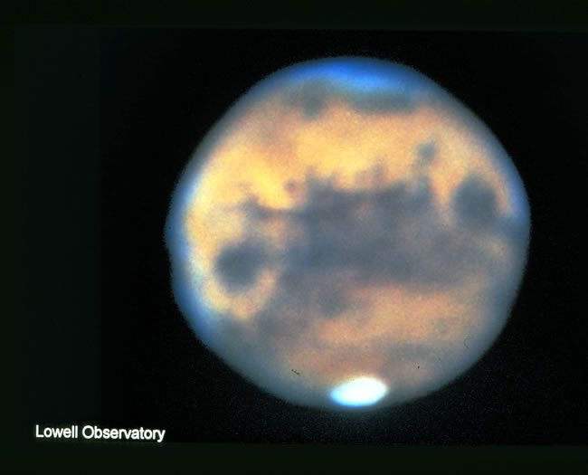
A. First we observe the given picture, drawn by Percival
Lowell, a businessman and astronomer who lived over 100 years ago. We then
compare it with the 2003 Mars Closest Approach picture to analyze Lowell’s
observations and his reasoning behind his analyzations.
B. We next observe pictures of Mars taken from Earth. Simple geographic features are identified and their
origin/history is questioned. This step also requires us to question why Mars’
size appears to change as it moves across the sky.
C. Two more images taken by the Hubble space telescope are
noted and we further analyze the surface in more detail.
D. Given information regarding the Mars landings of the
1970’s and more recent landings in the late 1990’s, we try to understand why
specific landing sites were chosen. The information provided by these many Mars
landings are investigated with the intention of better understanding the
formation and makeup of this planet.
E. Using the Google Mars map view online, Mars is observed
in both the infrared and visible lights as well as on a false color elevation
map. The landing sites of the Mars Exploration Rovers and the features of these
sites are recorded for further analyzing. Features of the planet that can be
made on one of the three maps, but perhaps not the others, are noted as well,
followed by thoughts on why these features exist.
Results and Discussion
A. Before his death in 1916, Percival Lowell drew diagrams
based on what he perceived he saw on the surface of Mars. It features and dark,
thin areas that appear to be canals and darker, thicker areas that have been
drawn to look like rivers. These features appear to lie on a lighter surface,
which Lowell may have thought was the land area around the apparent water.

During Lowell’s lifetime, canals were a major source of transportation.
Because of the world and culture surrounding him, it would be natural for him
to think forms of life elsewhere would behave similarly, should they exist.
Though we now know that forms of life elsewhere in the universe could function
differently even on chemical level, scientists in the 1800’s had to make
guesses about other life forms based on the information they already knew.
What Lowell was more likely seeing were the different rock
compositions in the different locations on Mars. The changes in color are due
to differences in the types of rocky materials on the surface rather than pools
of water or liquid.
B. The photos taken from the surface of Earth are blurry
relative to those taken from above the atmosphere. From the pictures taken from
the ground, the only apparent feature is the ice caps. These are caused by a
difference in temperature, likely from the indirect angle of sunlight at the
caps. There is variety in the surface color, but the images are not clear
enough to allow us to draw many conclusions about the surface. Looking exclusively at photos taken from
Earth, these areas may resemble craters or a difference in elevation.
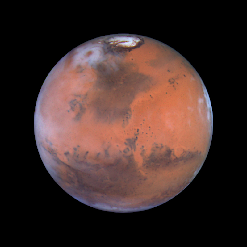
If we compare the images from Earth to those taken by
Hubble, we notice both show what appears to be a vast red “sea” on the surface.
The ice caps are also apparent in both photos. Details are much more apparent
from the space telescope, however. The Hubble pictures give a better idea of
what the surface looks like; it takes blobs of color and gives us an idea of
how the colors transition from one to another across the surface.
Mars has a lot of the same size craters as the moon, taking
into account that mars is larger in size. They are likely approximately the
same age. These are more visible in the Hubble pictures.
The S-Shaped image of Mars’ movement in the sky shows Mars
changing sizes over a period of months. Mars does not actually grow and shrink
over time, but it does move closer and further from the Earth. This phenomenon
happens just as it does with the moon and sun; distance from our eyes can trick
us into believing the size is larger or smaller than it actually is, relative
to other objects.
C. The two given pictures from the Hubble telescope still
show the ice caps on either end of Mars, as well as the contrasting red areas. They show the same features of Mars and the same surface.

The second image, however, is smaller because Mars was Farther from the Earth in September than in June. The planet did not actually change sizes.
D. We first landed on
Mars with the 1970’s Viking missions, according to the lab assignment, and we’ve
continued to do so recently. With the given map and Google Maps, we can see
that the surface of Mars is not uniform. The highest features on Mars appear to
be volcanoes on the west side of the planet. This could be why we have such a
difference in surface features in different parts of the planet; volcanoes
leave behind a new surface that is younger than the original.

In the elevation map of the planet, the most noticeable
difference between the north and south hemispheres of Mars is the smoothness of
the surfaces. The north is very smooth and new, while the south is more cratered
and much older, relatively. Most of the
impact craters are south of the Moon’s equator. The largest of these impacts is
in the southeast quadrant: Hellas Planitia.
After finding the landing sites of the Viking I and II spacecrafts
that landed on Mars in 1976, we can observe the surfaces they landed on. Viking
I and II both landed in plains regions of Mars. Viking I landed near what
appeared to be a canal structure on the surface. Scientists were probably
trying to see what made this structure and perhaps hoped to find evidence of a
liquid flowing on Mars’ surface. Viking II was near a crater on the northern
plains, but likely chose its spot because it would be easy to land there. This
way, Viking II could safely land before exploring the older regions of the
planet.

More recent crafts have been sent to Mars as well.
Pathfinder landed in the northern plains. Spirit and Opportunity landed in the
southern hemisphere in rockier areas resembling possible lakes or canals.
Spirit and Opportunity’s landing spots gave researchers the chance to find
information in areas not otherwise touched by previous spacecrafts.
The Soviet Mars 3 spacecraft only transmitted information to
Earth for about 14.5 seconds before stopping. This craft landed in a mid
elevation area with many craters and rocks. It could have hit a rock after a
strong wind affected it, leaving a broken machine on the surface of Mars.
E. The Mars Exploration Rovers landed at Gusev Crater and
Meridiani Terra on the surface of Mars.
The crater is near a large valley structure that resembles a river. The
Meridiani Terra is a smoother area, providing a clear landing space that may
have been the leftovers of an old sea bed. Meridiani Terra looks like a dried
water bed in infrared since the elevation does not change significantly in this
area. It is very flat. The Gusev Crater looks as though its craters are spewing
black strings all in one direction. In infrared light, these apparent strings
have an even more rigid structure. These strings are an unknown substance if we
only know what we see in the given images.

The Niger Valley of Mars looks like it was once a river
flowing into a larger body of water like a sea. This is likely a reason we, as
humans, have suspected water on the surface of Mars for so many years.
F. Some of the more recent crafts sent to Mars have been
focused on water and life. The Mars 2020, which will leave Earth in a few
years, will be a robotic explorer for our researchers. Insight, which is
planned to leave March 2016, will study Mar’s atmosphere and interactions with
the solar winds from the sun. Older crafts such as Pheonix, Mars Reconnaissance,
and Odyssey aimed to find water and life on Mars. Since we have not found water
or life on Mars on our many missions, though it could have existed in the past,
I think further research on Mars should focus on using the planet to teach us
about Earth. Studying the atmosphere and interactions with solar winds, etc,
could be helpful in better understanding our own planet with the added
flexibility of not having anyone there to harm. Many experiments can be
conducted on Mars because there are no creatures we could disturb. I think this
is an advantage in continuing our studies of Mars.
No comments:
Post a Comment