Introduction:
The images of Mars that have recently become available are tremendously useful in researching the planet. In this lab concerning Mars, we were able to discover more about the planet. We observed its surface using different materials. In addition to viewing the appearance of the planet’s surface, we also observed its physical makeup and became aware of the qualities of its surface.
Procedures:
In order to complete this lab, I had to utilize virtual maps of Mars, including http://www.google.com/mars/. I used the different available online images of Mars to view and compare its physical traits. Using additional sources to view Mars’ surface, I was able to further understand its complexities.
Results and Discussion:
A)
Percival Lowell was a businessman and astronomer who died 100 years ago in 1916. This is what Percival Lowell recorded that he saw on the surface of Mars when he looked through his telescope:

Compare Percival Lowell's drawings to one of the best images taken with the Hubble Space Telescope in 2003:

Percival Lowell thought he was seeing evidence of advanced intelligent people on Mars, es evidenced by vast canals spanning the planet.
- Why would Percival think he saw canals? (Hint: think about our own civilization more than 100 years ago. What were the dominant modes of transportation?)
Lowell probably described canals because there was no such thing as a real road system yet, only railroads and rivers.
2. What was Percival seeing instead?
He was probably seeing the canyons on Mars.
B)
Here are typical sets of images that can be obtained with Mars from telescopes on the ground (with digital cameras and careful observing practices):

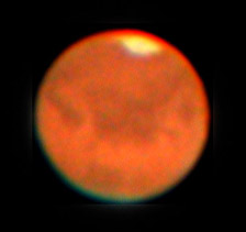

- What are the main features that you can identify from the images taken from surface of the Earth? What might be they caused by or produced by? Can you see anything that resembles craters, mountains, or seas?
From the surface of Earth, you can see the drastic change in elevation. These could be a result of volcanoes, lava flow, and possibly water movement. Yes, there is a possible sea visible.
- How are these ground-based images similar to the Hubble Space telescope image? How are they different? Why might our views of Mars be changing? Are they more detailed or less detailed?
You can still see the same pattern of the different shades of red. The Hubble images are much more clear. We have developed telescopes equipped with adaptive optics, which negate the atmospheric turbulence. Our views are more detailed as a result of this.
- How are these ground-based images similar to the Hubble Space Telescope image? How are they different? Why might our views of Mars be changing? Are they more detailed or less detailed?
Yes, Mars has a lot of visible craters. This means that it is relatively old.
- The “S”-shaped sequence of Mars-shaped images clearly show Mars appearing to change in size. They were taken over several months. What is going on?
It is getting closer and then farther away from the viewer.
C)
Here are two more images taken months apart with the Hubble Space Telescope:
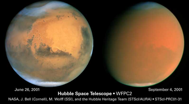
- What are the main features that you can identify in these images?
Hellas Planitia and Argyre Planitia are the main features visible.

- How are these two images similar and different?
The second imagine is the same reddish hue, but is clouded over, obscuring the details that are present in the first image.
- What is going on here?
It appears that a dust storm has overtaken the planet.
D)
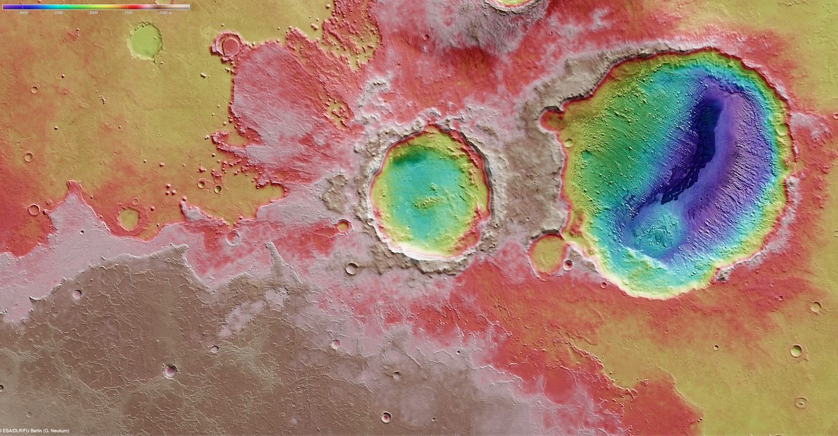
We first landed on Mars in the 1970s with the Viking missions, and have sent rovers to Mars for the past 20 years since July 4th, 1997, starting with the Mars Pathfinder mission. We have also sent a series of orbiters, including the Mars Global Surveyor spacecraft that operated until its batteries failed in 2006. Currently there are a total of seven spacecraft either orbiting (MAVEN, Odyssey, Express, and Mars Reconnaissance Orbiter) or roving the surface of (Curiosity, Spirit, Opportunity) Mars today. Use the images below. Google Mars shows a false-color relief (elevation) map of the surface of Mars, revealing many details about the planet.
- What do the four highest features on Mars appear to be? What could that mean?
The four highest features on Mars appear to be Olympus Mons, Ascraeus Mons, Arsia Mons, and Pavonis Mons.

- In the elevation map of the planet, what is the most noticeable difference between the Northern and Southern hemispheres of Mars? What might this mean?
The Southern Hemisphere is a much higher elevation than the Northern hemisphere, possibly indicating that the Northern hemisphere is a sea.
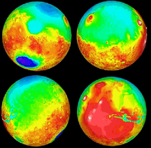
- Which hemisphere appears to have most of the impact craters?
The Southern hemisphere appears to have the most craters; the Northern hemisphere is nearly crater-free.
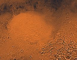
- What appears to be the largest impact crater on Mars?
Galle Crater Dunes appears to be the biggest crater.
- Find the landing sites for the US Viking I and II spacecraft, which touched down on July 20th and September 3rd of 1976 (40 years ago). What type of terrain did they land in? What do you think were the reasons for choosing these particular areas? From the elevation map, were they high or low elevation regions on the surface?
The Viking I and II spacecrafts landed in pretty even terrain, probably because it would be much easier to land where there aren’t many craters. They landed in low regions.
- Find the landing site of the US Mars Pathfinder, Spirit, Opportunity and Curiosity spacecraft. What type of terrain did they land in? What could have been the reasons for choosing these areas?
The Pathfinder, Spirit, Opportunity, and Curiosity rovers landed in a little more uneven terrain than the Viking spacecrafts, and are also in a higher elevation zone. They may have wanted to view what it was like in the more moderate elevation areas.
- The Soviet Mars 3 spacecraft was the first soft landing on December 2nd, 1971 at the Ptolemaeus Crater on Mars. Find it on your maps (https://en.wikipedia.org/wiki/Mars_3). After 14.5 seconds, transmission from the surface stopped. It may have fallen over, or there was a dust storm raging on Mars at the time that could have fried the electronics. Give a reasonable explanation for why it may have fallen over.
There might have been an extremely powerful dust storm that blew the spacecraft over.
E)
With the Google Mars map views (elevation, visible and infrared):
- Search for the landing sites of the Mars Exploration Rovers (Spirit and Opportunity). They landed at Gusev Crater and Meridiani Terra.
- Zoom in on each landing site and describe each site as to the features present and their elevations. Suggest reasons why these particular places might have been chosen.
The Spirit rover landed in the middle of a crater, at an elevation of approximately 1.5km below sea level. The Opportunity rover landed on a plain near a small crater, at about an elevation of 1.5km below sea level.
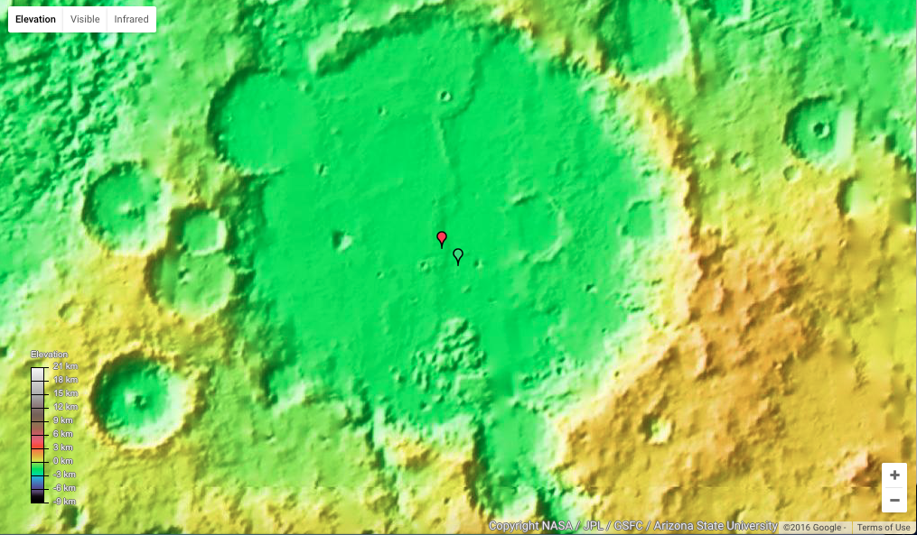
- Look at each landing site in the visible and infrared and determine whether you can see things in one wavelength of light that you cannot see in the other. Describe your findings.
In the infrared view, you can see a bunch of smaller craters and a small mountain near the Spirit landing site, but those features are not noticeable in the visible wavelength. The infrared view of the Opportunity landing site doesn't necessarily offer any new details, however the features present are much more visible.

- Search for Niger Valles using the Google Mars search tool. Increase the magnification and follow Niger Valles by eye from its high elevation beginning to its low elevation end. What seems to have been going on here? Describe your findings.
There seems to be a canyon that has eroded into the surface, but as it goes on, it tapers off into a vast area of the same low elevation.
F)
NASA spacecraft continue to explore MARS today. See http://science.nasa.gov/missions/. If you were planning the next mission to Mars, what would its goals be?
If I was planning the next mission to Mars, I’d be trying to find tangible lifeforms.
Conclusion:
I never realized how cool Mars is, or the differences in details that are visible in the different wavelengths of light. I gained a greater appreciation for the “great red planet.”
No comments:
Post a Comment