In this lab, we studied the surface of Mars to draw conclusions about it's past, it's composition, and it's landscape. By observing maps from different periods of time, we are able to better understand the planet in all it's complexity.
A) For the first part of the lab, we looked at what Percival Lowell saw when he viewed
Mars through his telescope. We then compared his drawings to a high resolution picture of Mars taken with the Hubble Space Telescope.
1. Percival probably thought he saw canals because of the darker lines an spots that marked the surface.
2. Instead of canals, Percival was seeing where previous rivers must have carved the land, leaving dark ridges in their places.

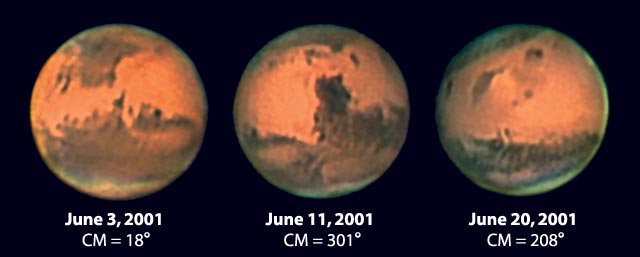
B) We then observed images taken from ground telescopes of Mars.
1. The main areas we can identify of Mars from the ground of Earth are the darker and lighter shaded areas. This is most likely because of different mineral compositions and possible craters or mountain ranges on the surface. These are probably impact craters caused by meteors that hit the surface long ago.
2. They are similar in that they are able to easily view the drastic contrast between the light and dark regions on the surface. They are different in that you can't see the white spot located on the south pole, as well as the many different variations of color found on the surface. Our views of Mars are changing because of the removal of Earth's atmosphere between us and Mars. These atmospheric interferences cause a lot of alterations to the planets one is trying to view. Nowadays, the pictures are far more detailed.
3. Mars doesn't have as many visible craters as the Moon or Mercury, possibly because there are winds that blow the dust around in the atmosphere, covering any impact craters that may have been there.
6. The "S"-shaped sequence of Mars shows the planet in stellar parallax, and on an elliptical orbit.
1.The two main features identifiable in these images are the light and dark regions, as well as the white "clouds" at the north and south poles.
2.These images are similar because they both differentiate between the lighter and darker regions. They are different because there is much less contrast in the second, leading me to believe that it is a different side of the planet.
3. I believe that we are viewing different angles of the planet.

D) Next, we looked at elevation maps of the surface of Mars, including one at www.google.com/mars, and drew conclusions about the surface using this.
1. The four highest features on the surface of Mars are Olympus Mons, Arsia Mons, Pavonus Mons, and Ascraeus Mons. These are large mountains, meaning at one point they could have been volcanoes.
2. One of the most noticeable differences between the northern and southern hemispheres is that the northern hemisphere is a lower altitude than is the southern.
3. The most impact craters are found on the southern hemisphere.
4. Hellas Planitia is the largest impact crater found on the surface of Mars.
5. Viking Lander I chose to land on an area between high and low elevation. This was most likely because scientists wished to study the conditions and differences between different levels of elevation on the surface. Although it was relatively smooth terrain, there were some impact craters. Viking Lander II, however, landed on an area of very low elevation towards the north of the planet. It landed next to a larger crater, but otherwise the terrain was smooth.
6. The US Mars Pathfinder landed in an area of low elevation with a slightly more rugged terrain, most likely to take pictures of the terrain. The Spirit landed in a crater towards higher elevation. This might be to take samples of the insides of the crater. The Opportunity landed in a heavily cratered area of medium elevation, most likely to take pictures of what an ordinary area on Mars might look like.
7. I believe that the failure of the Soviet Mars 3 was most likely because of a sand storm that was occurring at the time of landing. This would clearly be very damaging for any mechanism to endure, especially one with such delicate features as this one. The winds on the surface would have easily knocked it over, if it wasn't built to handle them.

E) Lastly, we focused on the Google Maps view of Mars.
1. (Picture of Gusev Crater and Meridiani Terra)
2. The elevation of the Gusev Crater is between -3 and 0 km deep. It is a large crater of 103 miles in diameter, with an overlapping crater as well. This is a very neutral zone to land a rover, and is very flat on the inside. Meridiani Terra is where the Opportunity landed, and is a vast plain covered in impact craters. It has an elevation of around -1 km, and was probably chosen because it is relatively near to other several different elevations that it could explore.
3. On the Gusev Crater, one can see infrared light. This might mean that it registers a different heat signature coming from the surface. On the Meridiani Terra, there is infrared light coming as well. This could possibly mean the same thing as well.
4. With the Niger Valles, it seems as though water is suddenly appearing from the surface of the planet, and flowing towards lower elevation (or at least this happened at one time). I believe this means that there is or was water underneath the surface of Mars, coming to the surface and forming rivers that flowed towards areas of lower elevation (as water would).

No comments:
Post a Comment