Megan Purgahn
Surface of Mars lab
Introduction:
In this lab, I had the opportunity to study multiple images of the surface of Mars. I was able to gain a lot of knowledge and understanding of what NASA and other space programs have been studying on Mars for the past decades. The purpose of this lab was to study the features of Mars, compare different images of Mars and study the different Mars rover landing sites. It is important to have some knowledge of Mars and its features as technology and space study progresses.
The materials I used during this lab included:
Images provided by Professor Plavchan and the following links...
https://www.google.com/mars/
https://en.wikepedia.org/wiki/Mars_3
http://science.nasa.gov/missions/
Procedure:
A.) I compared the drawings of Percival Lowell with images of Mars taken from the Hubble space telescope.
B.) I compared images of Mars taken form the ground with the images take from the Hubble telescope, and studied an image of Mars' s-shaped sequence.
C.) I viewed more images take from the Hubble telescope, and compared images taken months apart, by looking at the different features of each image such as color and elevation.
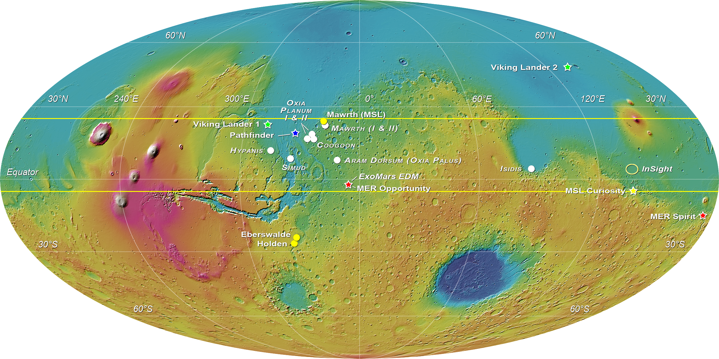
D.) I looked at the maps of Mars on google maps, and a printed map of Mars and studied many features on the surface of Mars, its elevation, the differences in hemispheres, and the spacecraft landing sights. I located the different spacecrafts of Viking I, Viking II, Pathfinder, Opportunity, Spirit, Curiosity, and Soviet Mars 3 and studied the terrain of each landing site.
E.) I used the elevation, visible, and infrared views of Mars on google maps to search for landing sights, and study features of the surface of Mars in different views and light.
Results and Discussion:
A.) Percival Lowell was a businessman and astronomer who died 100 years ago in 1916. This is what Percival Lowell recorded that he saw on the surface of Mars when he looked through his telescope:

1. Why would Percival think he saw canals? (Hint: think about our own civilization more than 100 years ago. What were the dominant modes of transportation?)
- Since the dominant mode of transportation 600 years ago was mainly boats, Percival probably believed he saw canals because he expected Mars and the other planets to have similar features of the Earth.
- He was most likely seeing craters, or different levels of elevation to that make some strips of land appear darker or he could be seeing flowing lava.
- Some of the main features that are visible from the ground are the darker and lighter areas, and the color variation.
- The different shades and colors may be caused by different temperatures, minerals, climates, or elevation.
- From these images, I can see areas on the surface that resemble craters, because there are dark, circular-shaped areas.
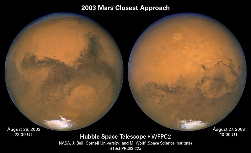
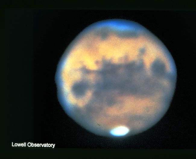
- The images from ground and from Hubble are similar because I could identify a lot of the same features in both images, like the large white spot, craters, and the different levels of elevation.
- The images are different because the images from Hubble are much clearer, better quality, and more detailed so it is easier to identify characteristics on the surface, while the images from the ground are very fuzzy and blurred.
- Our views of Mars are changing because the surface of Mars is constantly changing, and also new technology allows us to see Mars in even greater detail.
- The images from the Hubble telescope are more detailed.
- Yes, Mars does have some visible craters, but not nearly as many as the moon or Mercury.
- It does not have very many craters possibly because lava on its surface covered them all up, or Mars may be a newer planet that has not had as much time to get as many craters.
- Mars' orbit is not a perfect circle so from earth's view it gets slightly closer or further away causing it to look smaller and bigger depending on when we are observing it, this is due to retrograde motion.

1. What are the main features you can identify in these images?
- The main features I noticed about the image from June was the bright orange area in the middle, many small craters, stripes of different colors, and the variety of colors it has.
- The main features I noticed about the image from September was the dark orange coloring, and how smooth the surface looks.
- The images are both similar because Mars has a lot of the same coloring in each image, orange/red in the middle, and white at both poles.
- They are different because the image from June has many more visible features than the image from September.
- In my opinion, it looks like there is volcanic activity possibly occurring, or dusting moving around, or changes of elements and the atmosphere.
1. What do the four highest features on Mars appear to be? What could that mean?
- The four highest features on Mars appear to all be volcanoes.
- This means that there is volcanic activity on Mars, which shows that Mars is similar to earth because we have volcanoes as well.
- The Southern hemisphere has an overall much higher elevation, and also has many more craters. The Northern hemisphere has a lower elevation and is more smooth on the surface.
- This means that the two hemispheres have very different climates and atmospheres.
- The Southern hemisphere has more craters.
- A large crater in the southeast region of Mars, at low elevation, about 40 degrees south, 70 degrees east appears to be the largest impact crater.
- Viking I landed in the center/northern hemisphere, at semi-low elevation with very mild and small craters.
- Viking II landed in the northeast region, at low elevation, in a smooth area with no craters.
- They were probably meant to land in these spots because it was mainly smooth land that would be easy to land on and travel around.
- They both landed in low elevation levels around -3 km.
- Pathfinder landed in a smooth area, at low elevation, in the northeast region.
- Opportunity landed in the center of Mars, at around zero degrees in elevation, surrounded by lots of small craters.
- Curiosity landed in the east, right along the equator, in medium elevation with mild amounts of craters.
- Spirit landed in the east, in the Southern hemisphere, at medium elevation with mild amounts of craters as well.
- The reasoning for landing them in all of these specific spots is most likely because astronomers wanted to get a variety of features to test and study.
- It was in high elevation, on rough terrain, in a very unstable area that was not flat and it was near volcanoes as well which all factored into why the spacecraft fell over.
E.) With the Google Mars map views (elevation, visible, and infrared):
1. Search for the landing sites of the Mars Exploration Rovers (Spirit and Opportunity). They landed at Gusev Crater and Meridiani Terra.
2. Zoom in on each landing site and describe each site as to the features present and their elevations. Suggest reasons why these particular places might have been chosen.
- Spirit was at a semi-low elevation, surrounded by lots of small craters and one large flat crater. This spot was probably chosen because of the flat place to land inside of the large crater, at around zero elevation, and it is also a somewhat newer crater to study.
- Opportunity landed in an area at zero elevation, on a smooth surface with few craters. Thus location was most likely chosen because it is easy for the rovers to land and move around.
- The infrared image of Mars is much more detailed, refined, and it shows smaller features.
- There is a large dark grey area in the Spirit landing site that is only visible in the infrared.
- Niger Valles looks exactly like where a river once flowed at one point in time, especially since it has a specific path and flows from high elevation to low elevation.
F.) NASA spacecraft continue to explore MARS today. If you were planning the next mission to Mars, what would its goals be?
- I think the goals for the next mission to Mars is to be able to land a human being on Mars.
Conclusion
Mars has many similar features to Earth and other terrestrial planets. As we move forward with technology and space travel we are able to learn more and more about the surface of Mars, its history, and the possible life it contains. Through this lab I have learned about the different physical features on Mars' surface, how its different images compare to one another, where the US has landed rovers, and much more.
No comments:
Post a Comment