Seth Dowler
Lab: Surface of Mars
Abstract
In this lab students will identify,
via primarily online as well as physical maps, the surface of Mars and its
features, and speculate on the formations of these features. Through this an
understanding of the process and difficulty of studying Mars will be reached.
Introduction
Before the invention of the
telescope it was left up to the naked eyes of astronomers to describe and
record the features of Mars, among other planets. But since recent
technological advances have allowed clearer and clearer images of the surface
of Mars, we can now study with relative ease compared with the difficulties of
past centuries. Using precise methods, the atmospheres of Earth and Mars can be
navigated in order to yield more detailed images of Mars, which we will be
using to study its surface.
Procedures
The following resource, Google Mars, is essential to the project. http://www.google.com/mars/
Also needed to complete the lab is http://science.nasa.gov/missions/
Additionally, sites like Wikipedia.com can be utilized to research possible explanations to questions concerning the lab.
Students will use these resources
and the following maps to answer the following questions.
A)
Percival Lowell was a businessman and astronomer who died 100 years ago in
1916. This is what Percival Lowell recorded that he saw on the surface of Mars
when he looked through his telescope:

Compare Percival Lowell’s drawings
to one of the best images taken with the Hubble Space Telescope in 2003:

Percival Lowell thought he was
seeing evidence of advanced intelligent people on Mars, as evidenced by vast
canals spanning the planet.
1. Why would
Percival think he saw canals? Hint: think about our own civilization more than
100 years ago. What were the dominant modes of transportation?
2. What was Percival seeing instead?
B)
Here are typical sets of images that can be obtained with Mars from telescopes
on the ground (with digital cameras and careful observing practices):


1. What are the
main features that you can identify from the images taken from surface of the
Earth? What might they be caused by or produced by? Can you see anything that
resembles craters, mountains or seas?
2. How are these ground-based images similar to the Hubble
Space Telescope image? How are they different? Why might our views of Mars be
changing? Are they more detailed or less detailed?
3. Does Mars have a lot of visible craters like the moon at
Mercury? What does this mean?
4. The “S”-shaped sequence of Mars-shaped images clearly
show Mars appearing to change in size. They were taken over several months.
What is going on?
C)
Here are two more images taken months apart with the Hubble Space Telescope:
Looking at these two images, you can
still identify changes in the color of the surface of Mars.

1. What are the
main features that you can identify in these images?
2. How are these two images similar and different?
3. What is going on here?
D) We first landed on Mars in the 1970s with
the Viking missions, and have sent rovers to Mars for the past 20 years since
July 4th, 1997, starting with the Mars Pathfinder mission. We have also sent a
series of orbiters, including the Mars Global Surveyor spacecraft that operated
until its batteries failed in 2006. Currently there are a total of seven
spacecraft either orbiting (MAVEN, Odyssey, Express, and Mars Reconnaissance
Orbiter) or roving the surface of (Curiosity, Spirit, Opportunity) Mars today.
Use the images below. Google Mars shows a false-color relief (elevation) map of
the surface of Mars, revealing many details about the planet.

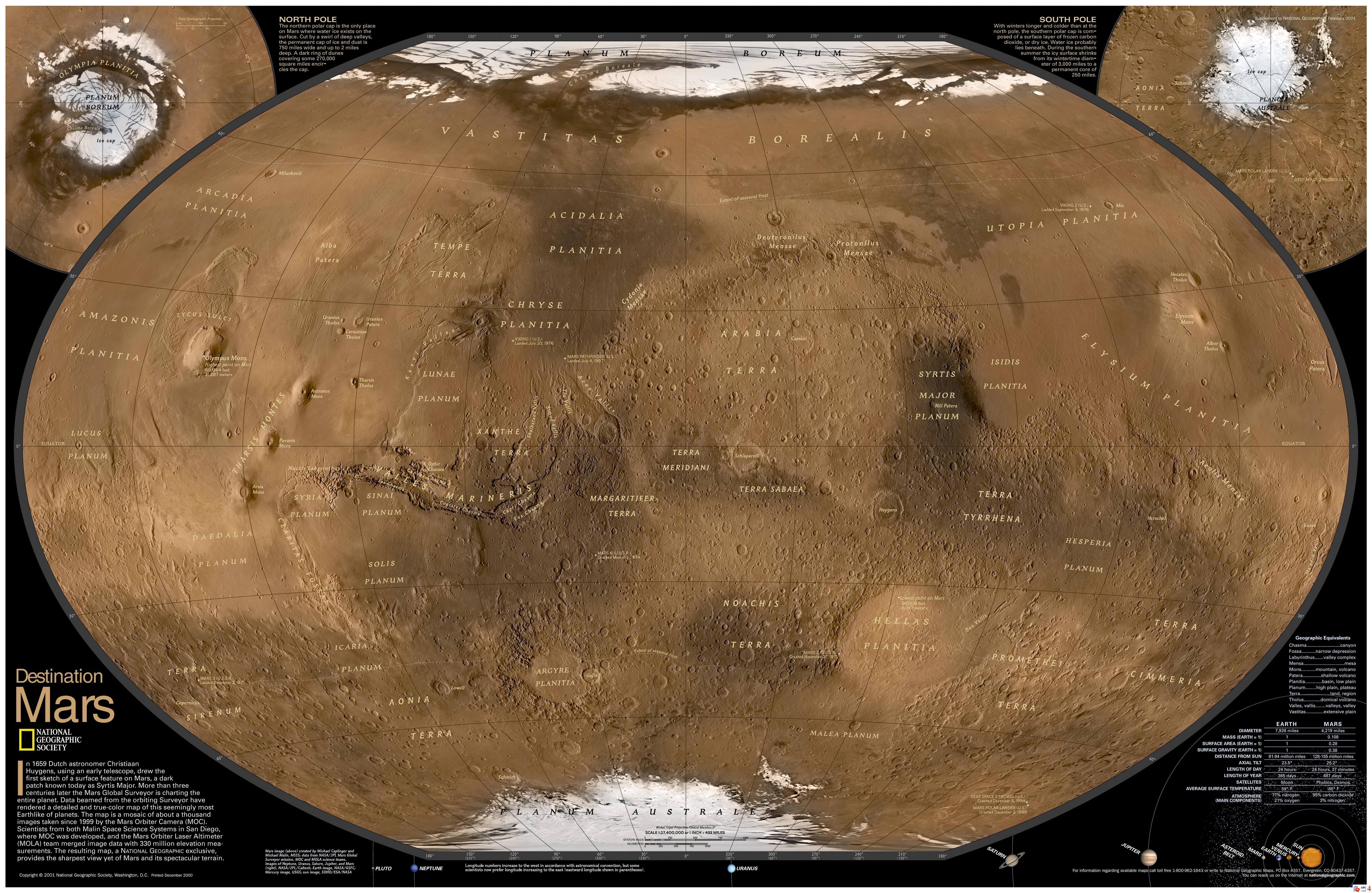
1.What do the four
highest features on Mars appear to be? What could that mean?
2. In the elevation
map of the planet, what is the most noticeable difference between the Northern
and Southern hemispheres of Mars? What might this mean?
3. Which
hemisphere appears to have most of the impact craters?
4. What appears to
be the largest impact crater on Mars?
5. Find the
landing sites for the US Viking I and II spacecraft, which touched down on July
20th and September 3rd of 1976 (40 years ago). What type of terrain did they
land in? What do you think were the reasons for choosing these particular
areas? From the elevation map, were they high or low elevation regions on the
surface?
6. Find the
landing site of the US Mars Pathfinder, Spirit, Opportunity and Curiosity
spacecraft. What type of terrain did they land in? What could have been the
reasons for choosing these areas?
7. The Soviet Mars
3 spacecraft was the first soft landing on December 2nd, 1971 at the Ptolemaeus
Crater on Mars. Find it on your maps. https://en.wikipedia.org/wiki/Mars_3
After 14.5 seconds, transmission from the surface stopped. It may have fallen
over, or there was a dust storm raging on Mars at the time that could have
fried the electronics. Give a reasonable explanation for why it may have fallen
over.
E)
With the Google Mars map views (elevation, visible and infrared):
1. Search for the
landing sites of the Mars Exploration Rovers (Spirit and Opportunity). They
landed at Gusev Crater and Meridiani Terra.
2. Zoom in on each
landing site and describe each site as to the features present and their
elevations. Suggest reasons why these particular places might have been chosen.
3. Look at each
landing site in the visible and infrared and determine whether you can see
things in one wavelength of light that you cannot see in the other. Describe
your findings.
4. Search for
Niger Valles using the Google Mars search tool. Increase the magnification and
follow Niger Valles by eye from its high elevation beginning to its low
elevation end. What seems to have been going on here? Describe your findings.
F)
NASA spacecraft continue to explore MARS today. See
http://science.nasa.gov/missions/.
If you were planning the next mission to Mars, what
would its goals be?
Results and Discussion
A)
1 + 2 [combined]. Percival thought
he saw canals, but what he really saw were probably places of erosion which
looked like constructions by intelligent life. The contemporary mode of
transportation – trains – likely influenced this perception. What eroded the
surface of Mars? Primarily wind, but also acidic fog which traverses the
surface of the planet. Additionally, the places in which Percival thought he
saw bodies of water were likely the dark spots: also places of erosion, in
which nearly all of the red dust has been swept away by wind.
B)
1. It seems too distant to make out
features as small as craters, but there do appear to be what could be
interpreted as seas on Mars looking from Earth, as well as possible mountains.
2. One of the ground-based photos
has similar coloring to the Hubble images, but the other two do not – they
feature lighter colors. More similarities are that all images include visible
dark spots, and all images also show what appear to be smaller places made by
erosion.
Our views of Mars are changing in
that, as technology advances, they become clearer and clearer.
3. Mars does not have many visible
craters. This implies that either it does not receive as many foreign object
impacts as other planets, or, more likely, that its surface is able to
withstand those impacts with less noticeable change: probably by those areas
being eventually covered by dust.
4. Mars orbits the sun slower than
does Earth – the s-shaped image shows it to become larger then smaller as the
distance between it and Earth shrinks, then grows. This is a demonstration of
retrograde motion because, as Earth’s orbit approaches Mars in its orbit, Mars
appears to slow, then go backward, then eventually begin its original
counterclockwise motion again.
C)
1. The main features I can identify
in the left side image are small areas of impact which I assume to be craters,
dark clouds surrounding the center of Mar’s middle of its surface, and ice caps
on its north and south poles. In the left image I see a relatively smooth
looking surface with substantially smaller iced areas, and two main portions of
differing color: a dark and faintly orange lower half and a brighter orange-red
top right segment.
2. As stated above, the main
difference is that the right image contains a much smoother surface, as well as
mostly lighter coloring.
3. What’s happening to cause these
differences seems to be due to the changing of the seasons: at the time of the
left photo (June), clouds dominate the surface of Mars and cause its darkness;
at the same time the polar caps form. At the time of the right image
(September), in contrast, these clouds have dissipated and the surface appears
smoother; the ice caps have melted substantially, too.
D)
1. The four highest points on Mars
appear to be mountains. These are, in order of highest to lower: Olympus Mons,
Ascraeus Mons, Arsia Mons, and Pavonis Mons. This could mean, as one
possibility, that Mars has experienced significant impact to cause these
formations.
2. The most significant difference
between the northern and southern hemispheres of Mars is that the northern is
substantially lower, below sea level, than the southern. This could be an
indication of Mars having a now-extinct large sea.
3. The southern hemisphere appears
to contain most of the impact craters.
4. The largest impact crater appears
to be in the Southern hemisphere of Mars. Its name is the Hellas Impact Crater.
5. These landings occurred in areas
of low elevation; both were below sea level. These areas were chosen likely
because of their relatively flat surfaces in comparison to other areas of Mars
(the ones in higher elevation with more impact craters). Also, the Viking II
landed next to a pretty substantial impact crater, likely to explore and
document its properties.
6. Pathfinder landed in an area of
-3 or so below sea level, near what appears to be a bed formed by water
previously, likely in order to explore said area, as well as surrounding impact
craters of which there were many.
Spirit landed in an area of slightly
higher elevation, in an impact crater which leads to another tributary-like
formation also likely formed by past bodies of water – likely to explore all
these places.
Opportunity landed in an area just
under sea level, nearing the southern hemisphere's overarching area of greater
than sea level terrain, likely to begin explorations of said area's contents.
Curiosity landed at the edge of an
impact crater which contains a large center point of heightened elevation,
assumedly to explore the terrain and surface of this point.
7. A possible explanation for the
transmission failure of Mars 3 is if the machine underwent corona discharge:
due to the raging winds of the dust storm, the fluid surrounding the conductor
of the machine could have been statically charged to the point of damaging the
communicative abilities of the machine.
E)
1. (Search for Gusev Crater and
Meridiani Terra)
2. At the Gusev Crater site, there
is a very large crater surrounded by a fair amount of smaller ones (about 1/10
of its size). Importantly, the crater's outer circular edge is not complete;
there is a trench or canyon formation that begins at its base. This probably
had a lot to do with why it was chosen, so the rover could follow this path and
explore the makeup of it.
At
the Meridiani Terra site, the surface is relatively flat, with a few complete
impact craters surrounding the site, along with a few incomplete impact
markings. Therefore it seems that mobility was the main concern here; the rover
was not impended by being stuck in a crater so it could navigate the terrain
and freely explore the surrounding formations.
3. At the Gusev Crater, there
appears to be little noticeable difference between the infrared and visible
spectrums when viewing the terrain, with the one notable exception that the
intricate mountain ridges are much more easily viewed with the infrared vision
rather than the visible vision.
The
only striking difference I noticed on the Meridiani Terra site is that there is
a plateau visible in infrared in the area just below the site, which is not so
obvious when viewed in the visible spectrum.
4. What appears to have happened in
the formation of the Niger Valles feature is that water was involved – that is
certain. As to what exactly happened, the most obvious speculation to me
involves ice. At the lower level there is a large circular area of low
elevation, which appears to have once been a sea. But because the Niger
formation rises up out of that area, it seems possible that expanding ice moved
upward into this area, a force which lead to its formation. An additional
possibility is that moving water somehow formed this through flooding.
F)
If I were planning the next mission
to Mars, I would want NASA to fund a rover to explore the inner region of the
Hellas Planitia – currently, only the Mars 2 Lander even attempted to land
close by, and it failed during descent. There are many possible discoveries to
be made, I believe, if we were to support a mission to this region.
Conclusion
This lab was performed in order to further our understanding
of the surface of Mars and the differences in technology which now allow us to observe it. In the past, the naked eye sufficed; gradually, advances in the technologies of telescopes and other imaging methods (infrared and elevation, for example) have allowed deeper understandings of the surface of Mars, which we explored in this lab.
No comments:
Post a Comment