Name: Trey Riley
Lab Experiment
#6: Surface of Moon
Date: March 22, 2016
Abstract
The purpose of this lab and this report is to study,
familiarize, and identify distinct surface features of Mars. Visible, infrared,
and elevation maps, as well as globes of Mars were analyzed extensively to
achieve the objective of this lab. Mars has distinct surface features much like
the Earth. Mars has mountains, valleys, ridges, craters, lowlands, highlands,
and distinct changes between each surface feature. Due to the lack of gravity
on Mars, the surface features found there are exaggerated. Mars holds the solar
system’s largest volcano, Olympus Mons, which has a diameter roughly the size
of the state of Arizona, as well as the deepest canyon system, Valles Marineris,
which is nearly four times as deep as the Grand Canyon. Un-maned expeditions to
Mars have been made, yielding a better understanding on the surface of Mars, as
well as its composition, both atmospherically as well as geologically.
Introduction
This report has six distinctive
experiments. The purpose in doing the first experiment is to examine what the
astronomer Percival Lowell observed on Mars in the early twentieth century
compared to what we know today in 2016. Lowell rendered a drawing of what he
observed. He believed he had found evidence of intelligent life on Mars by observing
what he thought to be an extensive canal system across Mars. This theory was
driven by the time which he was alive, since transportation by boat across
canals was becoming a major means of crossing large distances of ocean in
shorter amounts of time. What Lowell was actually observing seems to be the
elevation changes of what were once ancient oceans and rivers on Mars that has
now dried, leaving only the erosion caused by the effects of water.
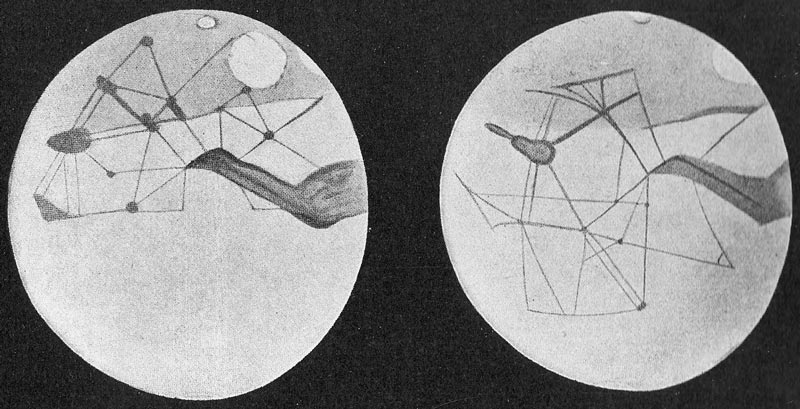 |
| Percival Lowell's rendering of the surface of Mars |
The second experiment conducted
consisted of viewing multiple photographs of Mars from the surface of Earth
without adaptive optics. Specific surface features were to be identified, and
then compared with the Hubble Space telescopes images. Some features that can
be observed from the surface of the Earth with a small refracting telescope
appear to be the polar ice caps at the North and South Poles, distinct changes
in elevation from mountain ranges to seas, as well as some of the largest
craters on the surface of Mars. From the Hubble Space Telescope, clearly
identifiable are the polar ice caps on the North and South Poles, distinct
changes in elevation from mountain ranges to seas, and also the amount of
cratering on the surface of Mars, yielding a better understanding of the age of
Mars. Mars was then to be compared to Mercury in the aspect of cratering.
Mercury is a heavily cratered surface, while Mars has a moderately cratered
surface. Therefore, volcanic activity has just recently ceased on Mars, in the
hundred millions of years, while volcanic activity on Mercury ceased some few
billion years ago. Finally the retrograde motion of Mars in our sky was to be
analyzed. As we catch up to and pass Mars in our orbit of the Sun, Mars becomes
bigger as we get closer, and as we pass Mars and move away, it becomes smaller.
 |
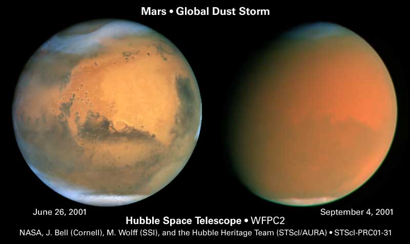
| Hubble (right) vs Earth (left) |
In the third experiment, two separate images
were taken of Mars months apart. These two images were to be analyzed, with the
similarities and differences noted. The main features that are identifiable are
the craters, changes in elevation, and the polar ice caps. The main similarity
between the two images is that the elevation changes is still visible, as well
as the polar ice caps. The difference being, that one is seems to be covered
with some type of opaque layer, while the other is easily visible. The opaque
image seems to point towards some type of dust storm raging on the surface of
Mars that would make light unable to pass through.
During the fourth experiment, an
elevation map of the surface of Mars was given to us, and was to be used. We
were asked about the highest features on the surface of Mars, which appeared to
be four separate volcanoes, all in somewhat close proximity to each other. The
differences between the Northern and Southern hemispheres were to be noted. The
Northern hemisphere of Mars contains the planets lowlands, three of the four
massive volcanoes on the planet, and has minimal cratering. The Southern
hemisphere of Mars has the planets highlands, one of the four massive
volcanoes, and a majority of all the cratering on the planet. There also
appears to be an extremely large crater in the Southern hemisphere, Hellas
Crater. Also, landing sites of certain rovers and spacecraft were to be found
and examined. Viking I and II landed in flat terrain, both in the Northern
hemisphere, and both near cratering. Viking I seems to have had a mission to
study the boarder of the lowlands to the highlands in the Northern hemisphere,
while Viking II seems to have had a mission to study the lowlands further
North. Pathfinder, Spirit, and Curiosity, are the rovers that have landed on
the surface of Mars. Pathfinder landed near Viking I on flat terrain on the border
between the lowlands and highlands of Mars in the Northern hemisphere.
Pathfinder’s mission may have been to examine the terrain differences and
craters near the border of the two different surfaces. Spirit landed in the Southern
hemisphere on moderately cratered and elevated ground. Spirit’s mission may
have been to examine the highlands surface features and craters. Curiosity
landed directly on the equator due east on moderately cratered and elevated
land. Curiosity’s mission may have been to go directly North and study a
massive volcano, or head due southwest and study Hellas Crater. The Soviet Mars
3 spacecraft also landed, but lost contact with Earth roughly fifteen seconds
after transmission. It may have tipped over due to its landing site, possible
ending up on the ride of a crater. If the ground was unstable, the spacecraft
could have fallen over and broken it’s electronics.
 |
| Length of Valles Marineris compared to United States |
Proceeding with the fifth experiment,
further examination of the surface of Mars was to be done with elevation,
visible, and infrared maps. Gisev Crater and Meridiani Terra were examined,
being where Spirit and Opportunity landed respectively. Spirit may have landed
near Gisev Crater because there is a river bed nearby to the South, as well as
other craters directly southeast. Opportunity may have landed near Meridiani Terra
because there are multiple other craters nearby, as well as what appears to be
a river bed to the west, while higher elevation is to the Southeast. While
examining each site in the visible and infrared, a clear difference between the
two can be discerned. In the infrared, much more detail of cratering, as well
as elevation change is clear. Finally, Niger Valles was examined. From higher
elevation to the lower elevation, Niger Valles seems to have been eroded by
water, possible an ancient river.
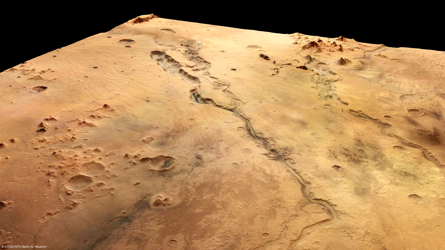 |
| Niger Valles higher elevation to lower elevation |
In the sixth experiment, we were giving
the opportunity to plan the next mission to Mars. If I were to plan the next mission
to Mars, I would be going to the Northern hemisphere, and find proof of either
water based erosion, or possible evidence of water still existing as a liquid
on the surface. Also, a chemical composition test of the polar ice caps would
be a secondary goal of a rover mission, to know the exact composition of what
is in the polar ice caps. Knowing exactly what is trapped in the ice can give a
look back into Mars not as distant past as an active planet.
Procedures
Throughout each individual experiment, a
certain type of map was consulted, as well as other pictures of Mars surface.
The types of maps used were elevation,
visible, and infrared maps. From each of these maps, information could easily
be discerned. If information was not clear enough, hi-def resolutions of photos
of the surface from NASA were examined to make a better explanation to the
experiment.
Results
and Discussion
Experiment One
Percival
Lowell examined the surface of Mars in the early twentieth century and found signs
of erosion and elevation changes, leading him to believe that what he was
seeing was an advanced culture mirroring that of Earth’s culture at the time.
If he had more resolute images of the surface of Mars, Lowell could have been
able to tell that what he was seeing was not canals and waterways created by an
advanced people. Rather, he was seeing lowlands and highlands forming borders
with different types of surface features.
Experiment Two
What
is observed from the surface of Earth looking at Mars is much different than
what is observed from the Hubble Space Telescope. Both can identify basic
features such as lowlands, highlands, polar ice caps, and extremely large
craters. The Hubble Space Telescope can more easily identify these features
with greater resolution due to the lack of atmospheric disturbance, as well as
being closer to Mars with a higher angular resolution, and surely with a larger
light-gathering area. Mars does not have nearly as many visible craters as
Mercury, due to having active volcanic activity much more recently than
Mercury. As Mars goes through its retrograde motion in our night sky, it
appears to become larger and smaller at certain points. This is due to the
Earth catching up to and passing Mars, meaning it is much closer, correlating
to the change in size from smaller to larger. Once Earth has caught Mars and
continues on its faster orbit of the Sun, Earth gets further from Mars,
correlating to the change in size from larger to smaller.
 |
| Retrograde motion between Earth and Mars |
Experiment Three
When the two
images are compared, there are some similarities and differences. In both
images, the polar ice caps, elevation change, and craters can be observed if
the image is closely examined. The difference being, in the second image, there
is much less definition and resolution to the image. The second image almost
looks monotone. This is due to a large dust storm raging on the surface of Mars
at the time the image was taken. The opaqueness caused by the dust storm
accounts for the monotonicity of the second image.
Experiment Four
The
highest features on Mars appear to be four individual volcanoes all within
relatively close proximity of one another. The most notable difference between
the Northern and Southern hemisphere is that the Northern hemisphere contains
the lowlands with few craters, while the Southern hemisphere contains the
highlands with a majority of the planets craters. The largest impact crater
lies in the Southern hemisphere. It is Hellas Crater, with a diameter of nearly
2300 kilometers. Viking I and II, Pathfinder, Spirit, Opportunity, and Mars 3
spacecraft all landed on and analyzed the surface of Mars in some aspect. Viking
I and II, Pathfinder, and Mars 3 all landed relatively near to each other in
the Northern hemisphere between the border of the highlands and lowlands on a
relatively flat surface that has minimal cratering. Curiosity and Spirit landed
further southeast on more elevated and cratered terrain than the aforementioned
spacecraft and rovers. Each spacecraft’s mission was different, but all
centered around the examination of the surface features of Mars, whether that
being craters, lowlands, highlands, volcanoes, valleys, or just geological
surveys.
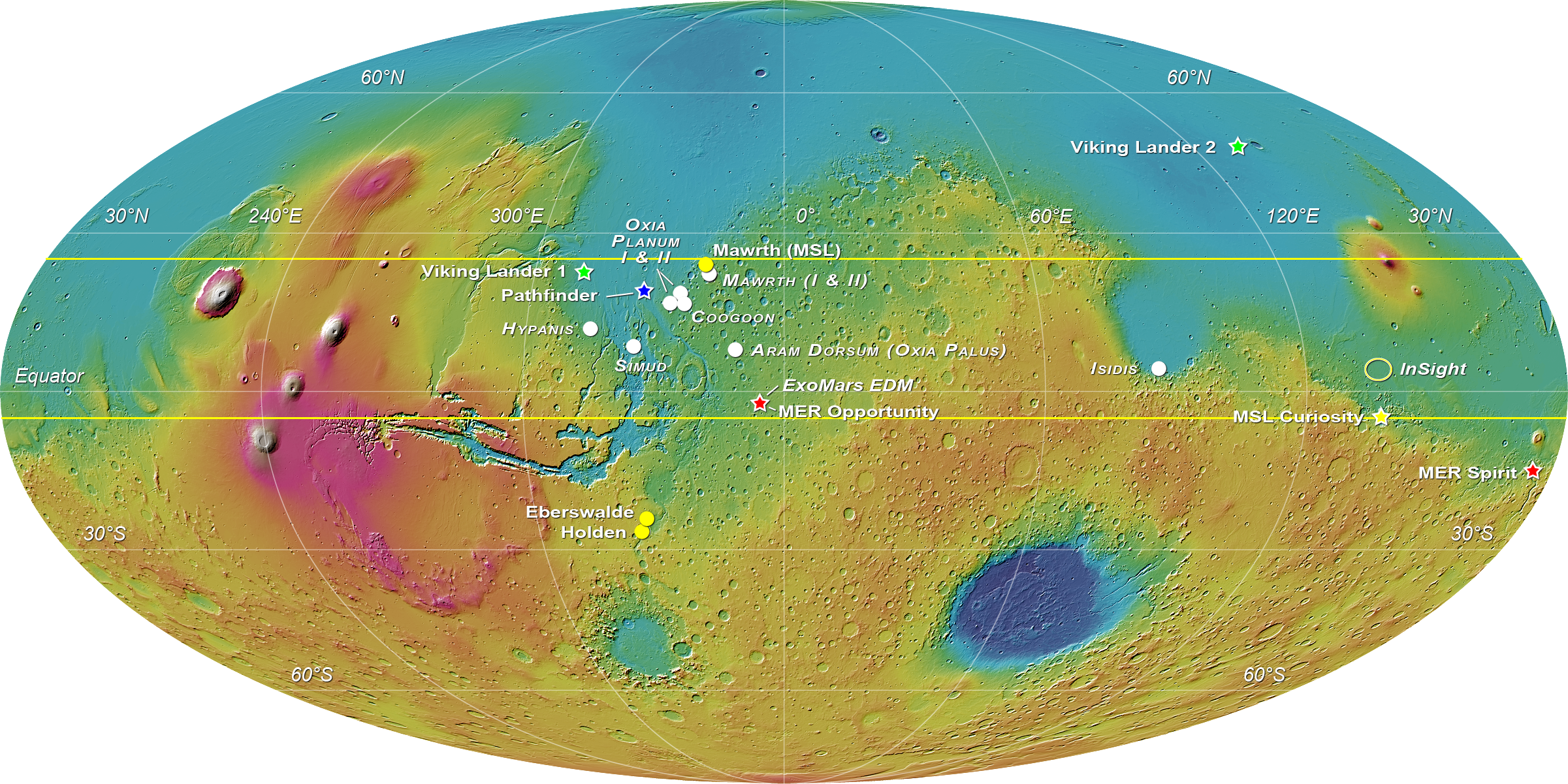 |
| Elevation map of Mars with landing sites of spacecraft |
Experiment Five
Spirit
landed near Gusev Crater because it was a large flat crater at moderate elevation
with a river bed nearby to the South as well as more craters to the Southeast. Opportunity
landed near Meridiani Terra because it is also flat land at a moderate elevation.
There are multiple craters as well as a river bed to the west, and also a
higher elevation to the Southeast. When the landing sites were viewed in
infrared instead of visible light, more craters were visible, as well as the
surface features around the landing sites became more detailed. In the case of
Niger Valles, following elevation from higher to lower, it appears to have been
an ancient river carved out by water erosion. Water flows from a higher
elevation to a lower elevation, and Niger Valles’ erosion looks comparable to
that of dry river beds on Earth.
 |
| Spirit and Opportunity landing sites |
Experiment Six
If
I were to plan the next mission to Mars, I would be going to the Northern
hemisphere, and find proof of either water based erosion, or possible evidence
of water still existing as a liquid on the surface. Also, a chemical composition
test of the polar ice caps would be a secondary goal of a rover mission, to know
the exact composition of what is in the polar ice caps. Knowing exactly what is
trapped in the ice can give a look back into Mars not so distant past as an
active planet.
Conclusion
The
objective of this lab and report was to gain a better understanding of the
surface features of Mars. This was achieved through visible, infrared, and
elevation maps, as well as globes of the surface of Mars. Mars has exaggerated
surface features, due to less gravity on the planet. Mars contains the largest
volcano and deepest canyon in the solar system. Mars was still active until a
few hundred million years ago to possible a billion years ago. Un-maned expeditions to Mars have been made,
yielding a better understanding on the surface of Mars, as well as its
composition, both atmospherically as well as geologically.
No comments:
Post a Comment